
Lavender Lake Copper-Gold Claim Group, located in NW Ontario for OPTION
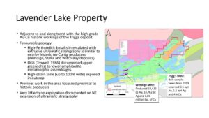
Option: The Lavender Lake claim group consists of ~880 hectares hosting significant copper and gold mineralization within an interpreted 2.5km shear zone between intrusive gabbroic and extrusive mafic volcanic contacts. The shear zones are on the same trend as other significant historical showings/mines and are potentially a secondary splay from a larger regional shear known as the Crowduck Lake-Witch Bay Shear Zone (also known as Gibi Lake Shear Zone).
Contact: Troy Gallik
Access:
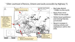
The Witch Bay property claims are located in Le May Township Code Township of the Kenora Mining District (Figure 2). Access to the properties is via the Witch Bay Road, which is in turn accessed from the Trans-Canada Highway (#71), a number of well-worn gravel roads, and along Highway 71.
The claims are located in lightly to moderately forested terrain, with common swamps and boggy areas. The topography can be described as moderately hilly with about 50 m of elevation change.
Regional Geology:
The Witch Bay area comprises the eastern part of the Lake of the Woods volcanic-sedimentary Belt within the western part of the Wabigoon Subprovince. The following is excerpted from OFR5629, Trowell 1986
Supracrustal rocks in the area consist of east to east-northeast trending volcanics and sediments. Most volcanics range in composition from mafic to intermediate. Felsic volcanics are uncommon. The mafic volcanics are flows and crystal and lithic-crystal tuff with the felsic to intermediate volcanics arpresent as pyroclastics (which are rare other than in the area south of Gibi Lake). The sediments consist of sandstone, mudstone, uncommon conglomerate and chert, and magnetite ironstone. Ultramafic and mafic intrusions as sills have intruded the volcanic stratigraphy. Tight isoclinal folding occurred about east-to northeast-trending northeasterly plunging fold axes. These early folds were deformed and reoriented by intrusion of granitoid plutons within and bordering the greenstone assemblages. Major shearing occurred along east to east-northeast-trending zones – Gibi Lake Shear Zone. Diabase dikes intruded along north northwest trending fractures. Late northeast to north-northeast-trending fractures are common. Diabase dikes are displaced by these fractures and in places pseudotachylites are developed along the fractures. The volcanics, sediments and mafic to ultramafic intrusions have been metamorphosed to upper greenschist to lower almandine amphibolite rank. Retrograde morphism has occurred, primarily along shear zones. Quartz-tourmaline and tourmaline veins and masses have extensively intruded the volcanic and ultramafic to mafic intrusions and to a lesser extent the sediments.
Property Geology:
The property is dominated by successive mafic flows and tuffs. Locally glomeroporhyritic mafic flows with white-weathering subhedral feldspar up to 5-6mm in cross section are present representing 10 – 15% of the rock volume. Flow top breccias are generally less than 2m in thickness and exhibit varying degrees of flattening. Rare arkosic sediments are in associated with flow top breccias. Pale pink aphanitic felsic dykes cross cut all units with their distribution implying a link to the Dogtooth Lake Intrusion. Metre-scale quartz-feldspar porphyry dykes are present throughout the property typically in or adjacent to shear zones. Fresh surfaces of the porphyry’s appear waxy in appearance reflecting abundant sericite and 2-3mm round quartz and fairly euhedral feldspar crystals averaging 10-15% of the intrusives.
Gabbro-peridotite sills intrude the volcanic sequence and are a deep green colour and range from fine to medium-grained in appearance. Although the groundmass appears to contain a significant proportion of hydrous mafic silicates, implying the rocks were affected by regional metamorphism, only a very weak foliation is generally evident except near the margins of most gabbroic bodies.
Numerous sub-metre foliation parallel shears cut the mafics with 5-10 m scale shears occuring along the mafic volcanic gabbro-peridotite sill contact. Breaks in the airborne magnetic fabric suggest the wider shears are linked to the Gibi Lake Shear Zone possibly as second order splays. Boudinaged quartz and quartz-carbonate veins accompany the shear zones. The quartz veins are mostly milky white with rusty orange patches, and a common saccharoidal texture also occurs in places. The rusty veins are mineralized with pyrite and chalcopyrite +/- bornite. The veins are oriented roughly northeast-southwest and occur subparallel to one another. There are numerous generations of veins. The auriferous vein set has yet to be identified from the general population of veins.
Two types of mineralization are present within the property:
- Quartz vein bearing shear zones along gabbroic and mafic extrusive contacts (F-35 Shear Zone)
- Massive sulphides within gabbroic units (Pogson Trenches).
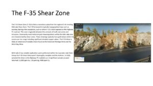
F-35 Shear Zone:
The F-35 Shear Zone (F-35) is likely a secondary splay from the regional E-W trending Gibi Lake Shear Zone. The F-35 is located in typically topographical lows such as swamps, baring a few exceptions, such as where F-35 is best exposed on the Highway 71 road cut. This zone is typically between the contacts of mafic extrusives and intrusives. Dominantly most historical gold showings/mines within the Gibi Lake area are characterized by shear zones. These showings typically have gold values within the ounces per ton range including significant elevated copper values. The F-35 shear is likely an extension of notable shears found at the historical Wendigo Mine and the Witch Bay Mine.
With lack of any notable exploration work performed within the Lavender Lake Claim Group the F-35 shear likely wasn’t thoroughly sampled until the Authors, in 2020, sampled the shear at the Highway 71 roadside cut. A significant sample assayed returned: 11,000 ppm Au, 1.8 ppm Ag, 4400 ppm Cu.
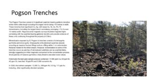
Pogson Trenches:
The Pogson Trenches consist of 4 significant sulphide bearing gabbroic trenches within 400m strike length including the largest trench being ~15 metres in width. These trenches host significant Cu, Ag, with lesser Au, Ni, Co, Pd, Pt mineralization, including the largest trench consistency averaging ~1% Cu over 15 metres width. Regional aerial magnetic surveys illustrate magnetic highs correlating with the sulphide bearing gabbroic trench’s and provide evidence of these units continuing throughout the property (>2.5km).
Mineralization exposed by G. Pogson in trenches consists of chalcopyrite, pyrrhotite and minor pyrite. Chalcopyrite is the dominant sulphide mineral, occurring as massive fracture fillings and as a filling within 1 cm wide tension fractures related to the minor shears. However, mineralization in some of the trenches occurs as patches of net-textured sulphides and as sulphide blebs, strongly suggesting an initial magmatic component to the concentration process. Small patches of massive pyrrhotite a likely linked to elevated nickel values.
Historically the best grab sample analysis contained: 14 980 ppm Cu, 64 ppm Ni, 42 ppm Co, less than 10 ppb Pd and 0.002 ounce/ton Au
In 2020, the Authors sampled: 13,200 Cu, 939 ppm Ni, 5.5 Ag, 117 ppb Au. Including, other significantly elevated samples.
Economical Potential:
Without significant exploration work performed the economical potential of the property is difficult to be determined. However, with the evidence of significant Au values within the F-35 shear zone and the significant Cu values and width of the Pogson Trenches, and the two types of mineralization located adjacent to each other, this property is in deemed necessary of significant exploration work.
Minimal initial exploration work is needed to be performed to create drill ready targets. At this time, the authors would recommend a SGH soils grid paired with detailed prospecting and outcrop mapping. As a result, drill ready targets could be ready for fall/winter drill programs. This property is one of the most “less risk high reward” properties within Northwestern Ontario, even compared to the Red Lake Area.